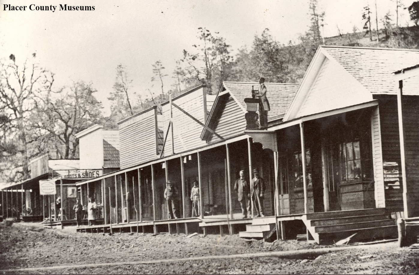
This is a fabulous photo from the Placer County Museums showing a portion of the business district of Colfax taken in the 1870s, during the town's heyday.
Highway 80
Auto headed up Meyers Grade just below the Alpine Club Summit Lodge. Photo: Donner Summit Historical Society, Norm Sayler Collection.
Meyers Grade to Johnson's Pass, Lincoln Highway in El Dorado County, Part 4
We have been discussing the route of the original 1913 Lincoln Highway through El Dorado County, and with our last post, we started the climb from the Lake Tahoe Valley floor up Meyers Grade towards Johnson’s Pass. The photo above shows an automobile making the climb from where I believe the present Highway 50 passes. There are only a few flat spots along the grade, and one such spot is where Meyer’s Grade Road passes over the present-day freeway. In the map below, we show where this photo, #1, was taken. When the present freeway was built, some of the original section of the last climb up to the pass was destroyed. We believe the car is where the present-day freeway passes.
This section from Highway 50 up to the pass was considered the last major obstacle on the way to the promised land of California. This is likely the steepest ascent yet, and you can still drive this section! Imagine trying to pull with oxen a wagon full of your goods up and over this section. Early automobiles would often break down, trying to navigate this last section and call for help from the Celio Ranch, in Meyer’s. In the photo below, we see the 1919 Army Convoy members being assisted by a caterpillar tractor.
1919 Army Convoy on Meyers Grade getting an assist from a Caterpillar tractor.
The photo below is a TC Wohlbrück photo showing his car in about the same spot as the photo above with the Army Truck. At this point we are almost at the summit, maybe less than a quarter of a mile away. Imagine driving this dirt road after rain!
A Theodore Wohlbrück photo from a few later than the Army Convoy photo at the same hairpin turn.
Once you reached the top of the pass after 1922, you would be greeted by a Canteen Service Station run by Theodore Wohlbrück. There you could pick up supplies, get water for the radiator, and have a bite to eat while enjoying the spectacular view. In our next El Dorado County Lincoln HIghway post, we will look at that Canteen service station and the summit pass.
The view looking east towards Lake Tahoe from Johnson’s Pass.
The Yuba River at Big Bend
This beautiful scene is looking east from the Rainbow Lodge, where we can see the present bridge crossing at left, built-in 1928. This is the south fork of the Yuba River, which provides a natural passage through the Sierra Nevada mountains. The river begins near Donner Summit and flows through Summit Valley, Soda Springs, and eventually here where it makes a “big bend”.
Big Bend is a natural crossing spot for travelers starting with the native people who inhabited this land. The first pioneers to come this way where the Steven-Townsend-Murphy party and their covered wagons. Some of the party over-wintered here, and one of their party, Moses Schallenberger, was caught in a snowstorm and spent the winter of 1844 in a tiny cabin on the east shore of Donner Lake. He was eventually rescued, and the cabin he stayed in was put to use a couple of years later in 1846 by members of the Donner Party.
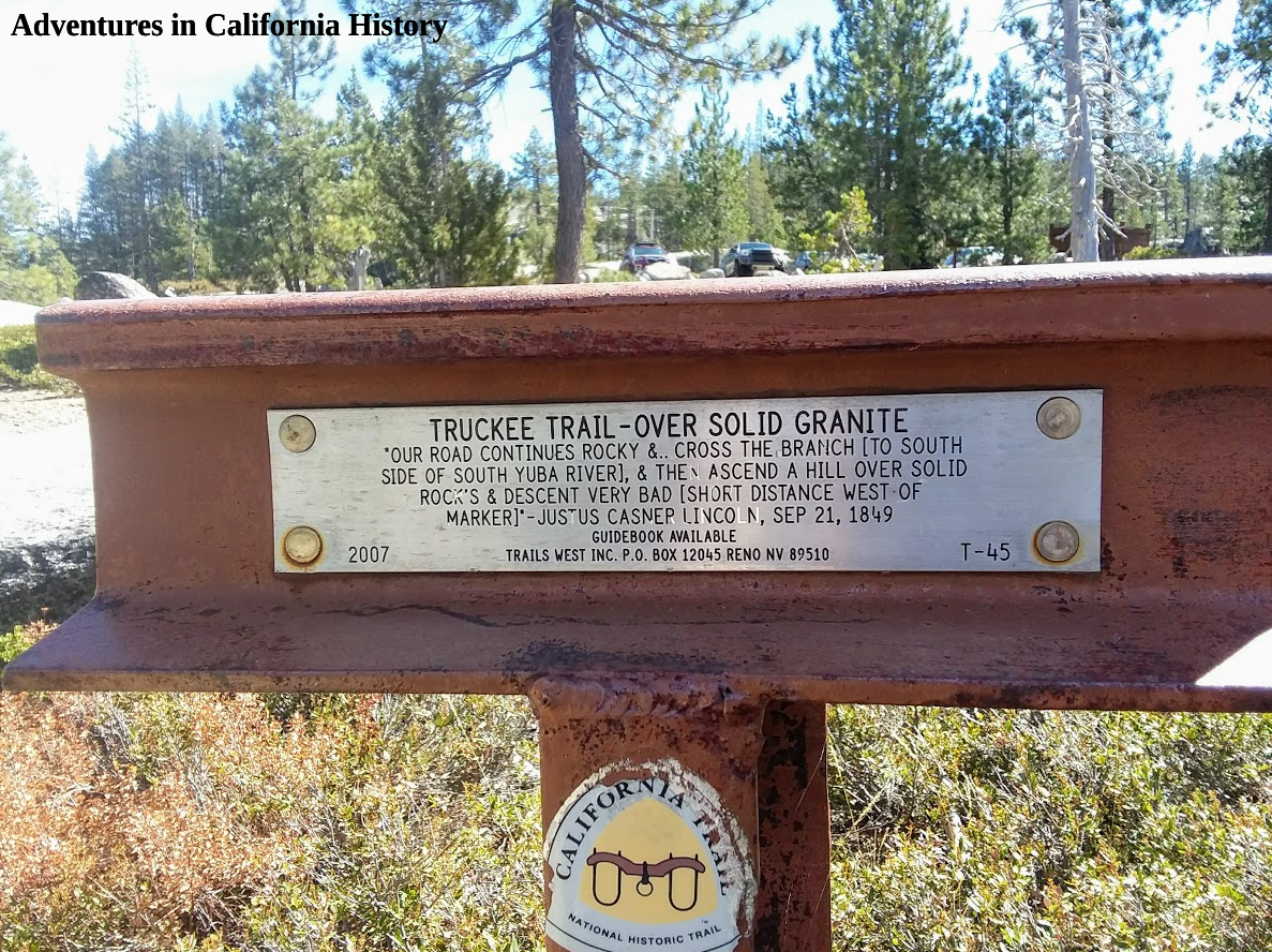
There are emigrant trail traces still to be found in Big Bend. Trails West Association has two of its “T” markers in Big Bend. These markers are placed on or near the original emigrant trails, and each has a quotation from an emigrant diary describing the place where the markers are today. The one pictured above is located just 50 yards north of the Lock Leven Trailhead parking (see map).
The emigrants lowered their wagons down the rocks and followed the S. Yuba River, staying on the south side, where the trail, after crossing today’s Hampshire Rocks Road, follows the Dutch Flat Wagon Roads path. Today the trial is named “Old Wagon Road” and follows the river for about a 1/2 mile.
This section of the trail on Old Wagon Road is magical as you are walking on all the trails at once. Following in the pioneers' footsteps, we cross a Lincoln Highway era concrete bridge and another creek with an old metal culvert exposed.
Metal Lincoln Highway era culvert.
Soon we reach the Trails West “T” Marker #46, which lets us know that this is where the emigrant trail leaves the route of the Dutch Flat Wagon Road and heads up the hill. They couldn’t proceed any further as the rock cliff juts into the water, making passage impossible for the earliest travelers.
In the photo below, we see the emigrant trail heading up the hill, past our bikes, while the Dutch Flat Wagon Road continues, following the river. The builders of that road used rock retaining walls so the trail could continue along the river. These retaining walls over 100 years old still support the old roadbed.
The emigrant trail goes left and up, past our bikes. The Lincoln Highway continues starlight.
We followed the emigrant trail markers for a bit, as we had heard there was a pioneer grave somewhere along the trail near here. The photo below shows the emigrant trail's view back down to our bikes leaning against the “T” marker. Once again, we are amazed at these early travelers' perseverance making climbs such as this with all their possessions in a wagon pulled by oxen.
Looking down from the emigrant trail. You can see our bikes leaning against the “T” marker.
We couldn’t find the pioneer grave and decided to head back down to the river and the road. If you follow the Dutch Fat Wagon Road/Lincoln Highway further west, you rise above the river and can admire the fantastic rock work used for this section. Check out the two photos below taken 100 years apart.
Theodore Wohlbrück photograph cutesy of the Donner Summit Historical Society, Norm Sayler collection.
Looking east on the old Lincoln Highway above the S. Yuba River, Big Bend.
The above photo is taken near the end of the old road, which was destroyed during Interstate 80. Below is a map showing some more of the features mentioned in the post. Fall is an ideal time to visit as the trees start to change color, and the temperatures make for great biking or hiking weather.
Through this narrow passage in the Sierra Nevada mountains, thousands of pioneers and later motorists passed on their way to the Golden State. Big Bend is etched into California History.
Map showing the location of certain features along the emigrant trail in Big Bend.
Big Bend, crossroads in history.
This is an intriguing photo taken by T.C. Wohlbruck of the Big Bend Ranger Station on the Lincoln Highway. We know it’s a TC Wohlbruck photo by the distinctive handwriting and numbering on each of his photos. These photos were taken with the idea of using them as souvenir postcards at his three canteen service stations located in the Sierra Nevada's high country.
Big Bend is rich in history as a resting place along the old Emigrant Trail, the Dutch Flat/Donner Summit Wagon Road, a county road , The Lincoln Highway, Highway 40, and today Hampshire Rocks Road. We see the Lincoln Highway passing by the Big Bend Ranger Station building on the left in the above photo. The road makes a sharp right-hand turn as it heads east, up the mountains towards Donner Summit.
At this time, Highway 40 was still a dream, so the Lincoln Highway followed the old Dutch Flat Wagon Road, which had been built by the Central Pacific Railroad to ferry men and supplies up the mountain for Transcontinental Railroad construction in the 1860s. Once the road was built, the Central Pacific opened it as a toll road, which was very popular. Once the railroad was completed, much of the traffic took the train instead of the wagon road, and the railroad turned it over the counties it passed through. In this case, it became a Placer County Road until 1913 when it became part of the Tranconental Lincoln Highway.
In the above photo, we are standing in the same spot 100 years later. In 1932 Highway 40, the predecessor of the Lincoln Highway was completed through Big Bend. As we can see, the road cut straight ahead, bypassing the sharp right turn the Lincoln Highway made. The Ranger Sation in the older photo has been replaced by a larger Fire and Ranger Station set back a bit from the road at left. We can barely see the old Lincoln Highway turn just past the no-parking sign at the right.
Once you make that right hand turn these days, you will come upon this scene, where we see Monica riding her bike on the old road. There is a large red building along this stretch, but we don’t know what it was used for back in the day. It does appear to have been a barn at one point in its existence. Check out the narrow pass between those large rocks. Between those two rocks traveled the thousands of gold-seekers, emigrants, railroad workers, and transcontinental travelers that used this section of road between the 1860s and 1932.
In the above photo, we are looking west just past the two large rocks.
We see Monica on the old road in the photo below, having just passed by the red building while walking east. The old road eventually curves back out and reconnects with Hampshire Rocks Road, where it would follow the same path until reaching the Hampshire Rock Campground, about a quarter-mile away.
The Big Bend area is a historians dream location. So many old trails pass through here, with stories of survival from the early days. This was the place where the Steven’s-Townsend-Murphy Party spent the winter after having been the first wagon train to cross the Sierra in 1844, even before the ill fated Donner Party’s attempt. An entire day can be spent enjoying and exploring this amazing place.
Below is a map of the area showing the key features.
Photo: Donner Summit Historical Society, Norm Sayler Collection
Once upon a time at "Lookout Point", Emigrant Gap.
Emigrant Gap’s name came from 19th Century travelers who used this narrow ridge and gap to continue their travels to the Bear River Valley. The emigrants would have to lower their wagons down a very steep slope to reach the Bear River Valley far below. The site soon became known as “Lookout point” and was separate from the small town of Emigrant Gap, located about a 1/2 mile to the south-east.
The photo above shows the first visitors building to occupy this spot, a Pacific Gas & Electric Company (P.G.&E) lookout, built so travelers on the Lincoln Highway could stop and view Lake Spaulding's 1913 construction, a project of the power company. Notice the Lincoln Highway sign at the far left.
The photo above was taken by TC Wohlbruck, who purchased this property from LB Allen, who owned a hotel at Emigrant Gap. We can tell it’s a Wohlbruck photo from the distinctive writing on each of his pictures. He would sell these photos as postcards from his Canteen/Service Stations at Echo Summit, Donner Memorial State Park, and Emigrant Gap. Wohlbruck was one of the first people to recognize the profit potential in offering service for the new-fangled autos and their drivers. We can see the Lincoln Highway heading off to the left of the entrance to the Canteen.
A Wohlbruck photo above shows the Cafe that was a part of the “Lookout Point Hotel”.
Another Wohlbruck photo above showing the sleeping quarters of the “Lookout Hotel.” Walking out the doors, guests would confront the amazing view and cliffs leading down to the Bear Valley.
Photo: Donner Summit Historical Society, Norm Sayler Collection.
The above photo comes to us from the TC Wohlbruck era and shows the curved rockwork at the Canteen/Service Station. Herstle Jones, who built the later Nyack Lodge, was assumed to be the stonemason that put up this wall. Herstle and his brother Oscar were expert stone masons and constructed or added to the Rainbow Lodge at Big Bend and the Soda Springs Hotel. This photo shows that TC Wohlbruck was the one who built the wall that would become part of the Nyack Hotel.
The construction of the Nyack Hotel in progress on the now renamed Lincoln Highway, “Hi-Way 40”.
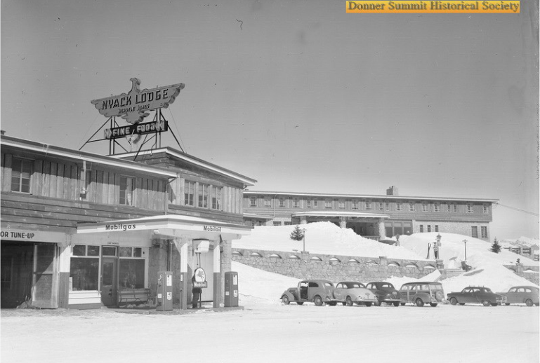
The above photo shows the completed Nyack Lodge, owned by Herstle Jones. We can see beautiful stonework in front of the building.
The photo above shows the service station component of the Nyack Lodge complex. E. Stewart Wells, whose family still runs the Nyack Shell nearby, was the service station operator.
Here we see a color photograph of the interior of the dining room of the Nyack Lodge. Guests looked out over the precipitous cliffs to the Bear Valley and Spaulding Lake, far below.
Here we have a great color photo of the cozy interior of the lodge with a lit fireplace. Notice the fantastic rock work which was a signature of the lodge.
Nyack Lodge Menu from the 1940s.
Donner Summit Historical Society, Norm Sayler Collection
With the construction of Interstate 80 in the early 1960s, the Nyack Lodge faced a crossroads. They needed a bit of space from the Southern Pacific Railroad, but with that company's refusal to release a portion of their land to make the necessary room, the lodge's fate was sealed. The massive building was destroyed, but the service station building was cut into three sections and moved a short distance to today's Nyack Shell Station site. The present-day service station is part of the old lodge complex! The old lodge was well built, and the demolition crews used explosives to take the rest of the building down.
The above photo from the 1960’s shows the parking lot that has replaced the older buildings at “Lookout Point”, Emigrant Gap. This is the scene we are familiar with today.
Map of the location and certain features.
Yesterday and today on the Lincoln Highway, Big Bend.
This 1920 photo by TC Wohlbruck shows the south fork of The Yuba River below the northern route of The Lincoln Highway at right. This section of the old roadbed is still pretty intact and walkable for being over 100 years old with no upkeep.
About the same location as the 1920 photo. Notice how well the rock wall has weathered.
The photo below shows the construction of the Highway 80 overpass near Big Bend, in the early 1960s. The road below is Highway 40, complete with thick traffic, part of the reason for the interstate's construction. We can see the earlier Lincoln Highway and overland Emigrant Trail passing under the bridge to the right of the river. Just beyond the bridge is where the first two photos were taken.
The map below shows the location. The blue line is the Lincoln Highway.
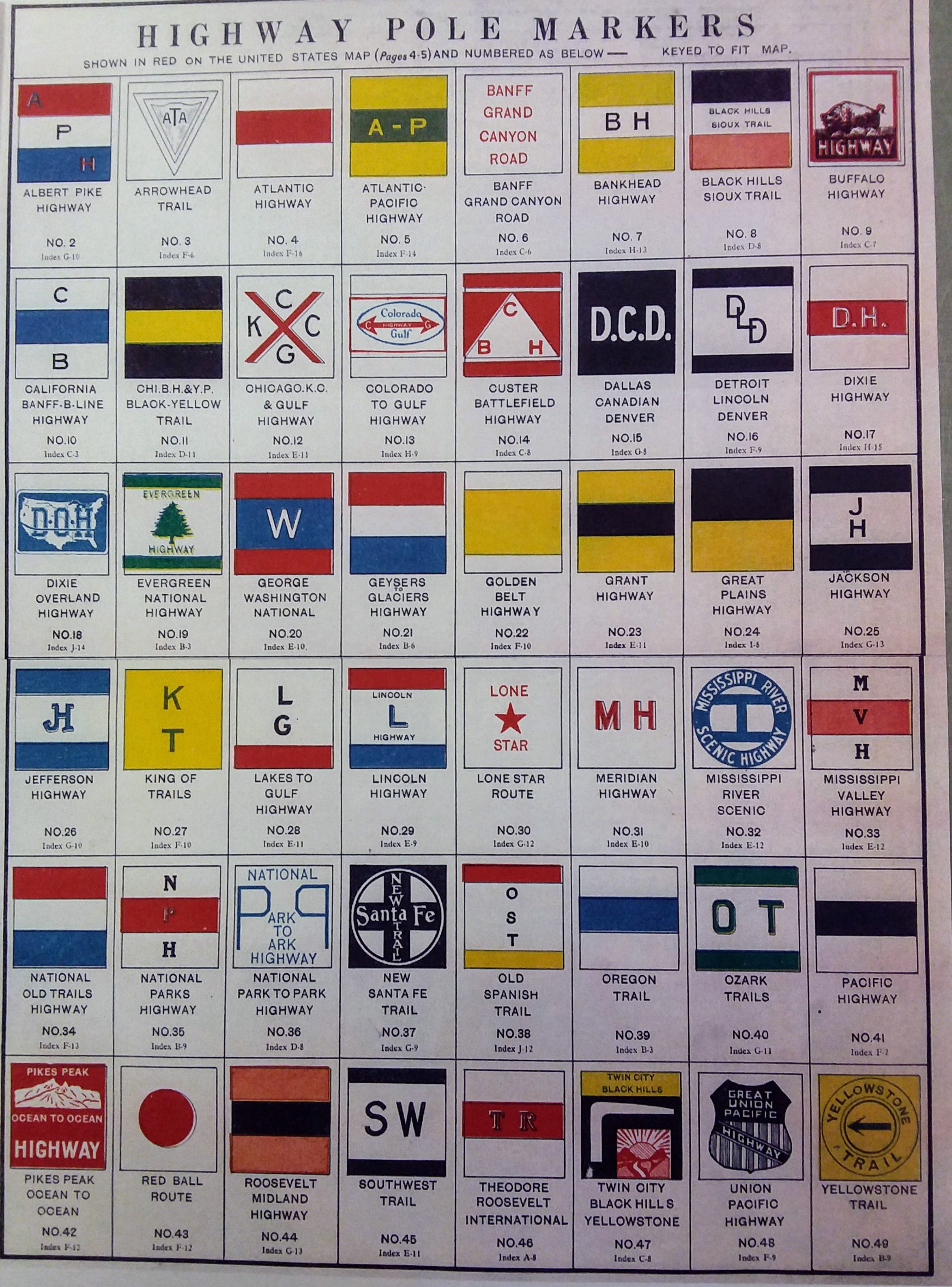
Highway pole signs from Donner Summit Historical Society, Norm Sayler collection
Historic highway pole markers
Before there was Interstate 80, or Highway 50 roads had names like Lincoln Highway or Yellowstone Trail. These pole markers guided motorists or “autoists” as they traveled to their destination. The emblem would be either painted on telephone or telegraph poles or warped around and secured in the case of metal signs. You would find them where a critical turn was needed, or just to let you know you were on the right path.
T Marker #33, just of Dog Bar Road, and Henness Pass Road. Monica found the glass piece on the old trail.
Lincoln Highway, Emigrant Gap
Monica and I spent a couple of days camping at Prosser Creek Reservoir, just east of Truckee. The reservoir filled a canyon with historic crossings, both The Overland Emigrant Trail, as well as the first generation of The Lincoln Highway. We were able to follow the old trails and enjoy some spectacular scenery.
Trey and Norm talking in The Donner Summit Historical Society Museum at Soda Springs.
The highlight to our trip was The Donner Summit Historical Museum, in Soda Springs. This small museum has more Donner Summit History than any other museum I know. It's run by Norm Sayler, who for over 40 years owner and operated The Donner Ski Ranch. He has amassed a collection of Donner Summit memorabilia and photographs that is unparalleled. We spent over 5 hours during two days talking with Norm and going through his amazing collection. There is so much to see and take in that it will require many more trips up to Donner Summit and Soda Springs to help record and preserve what is stored there.
This photograph shows two ladies standing in front of The PG&E (Pacific Gas and Electric) lookout station at Emigrant Gap, around the 1920s. This location is now a large turnout and vista point along Highway 80. If you look closely, you can even see a Lincoln Highway Directional sign on the left of where the women are standing.
The PG&E Lookout at Emigrant Gap, 1920’s. Photo from Donner Summit Historical Society, Norm Sayler Collection.
The photograph below shows two women on skies near Cisco Grove. Notice the Lincoln Highway Sign buried in the snow and The Transcontinental Railroad Snow Tunnels on the hillside.
Notice the Lincoln Highway Sign buried in the snow! Photo from Donner Summit Historical Museum, Norm Sayler collection.
